I left Wells this morning and headed north on US93 toward Twin Falls, Idaho, about 120 miles north. You can see from the picture below what the terrain was like:

As you can see, it was pretty typical of the rest of Nevada...dry and desert-like. I did run across a couple of these animal overpasses. I had seen them several places last year in Canada, but I had never seen them in the States before:

It was interesting to see how they did it. They had build high (probably 10 feet) fences all along the road (both sides) that extended for a couple miles in both directions. As they got closer to the overpass, they got closer to the road until the overpass was the only opening through which the animals could go. Sort of like the base of a funnel. Interesting...
I got to Twin Falls, Idaho around 11:00 or so. To the north of the city is the Snake River Canyon where they had a very impressive scenic overlook. Here are a couple shots from the overlook:


This next shot was taken about 10 miles north of the Canyon in what was a very large, fertile farming region. Contrast this with the first picture taken about 10 miles north of Wells, NV...only about 120 miles apart.

From Twin Falls, I continued north on US93 and US20 toward Craters of the Moon National Monument. Pat and I had visited here in 1978 and I remember how striking the area is. I started seeing lava deposits around Richfield and the further north I went, the more prevalent they became. This would be tough country to try to sink a plow into. I took this picture alongside the road near Carey, Idaho:

These lava deposits just kinda blended in with the landscape and they had plants growing (poorly) all over them. Further up the road was the entrance to the National Monument itself and the view became all the more striking:

The sign was a couple miles south of the Visitor's Center. The Monument itself encompasses 750,000 acres (over 1,000 square miles) in south-central Idaho. The oldest lava flows are thought to be about 15,000 years old while the latest are thought to be about 2,000 years old. Here are a few pictures of the more interesting areas:


Really, a much larger volcanic area than Sunset Crater outside of Flagstaff that I had stopped at last week.
I continued along US20 toward Idaho Falls and stopped at the EBR-1 Atomic Museum near Atomic City, about 50 miles west of Idaho Falls. Unbeknownst to me, this area was a hotbed of research in the early years of the Cold War. EBR-1 was an "Experimental Breeder Reactor" and was the first application of Atomic Energy to generate electricity. On December 20, 1951 the reactor first produced electricity and the next day the facility was able to generate enough electricity for its own use. In 1953 the reactor began to "breed", producing plutonium which was then used to power the reaction, in effect, producing more fuel than it used. The facility was used as a research facility until the 1980's. The building itself is not very imposing:

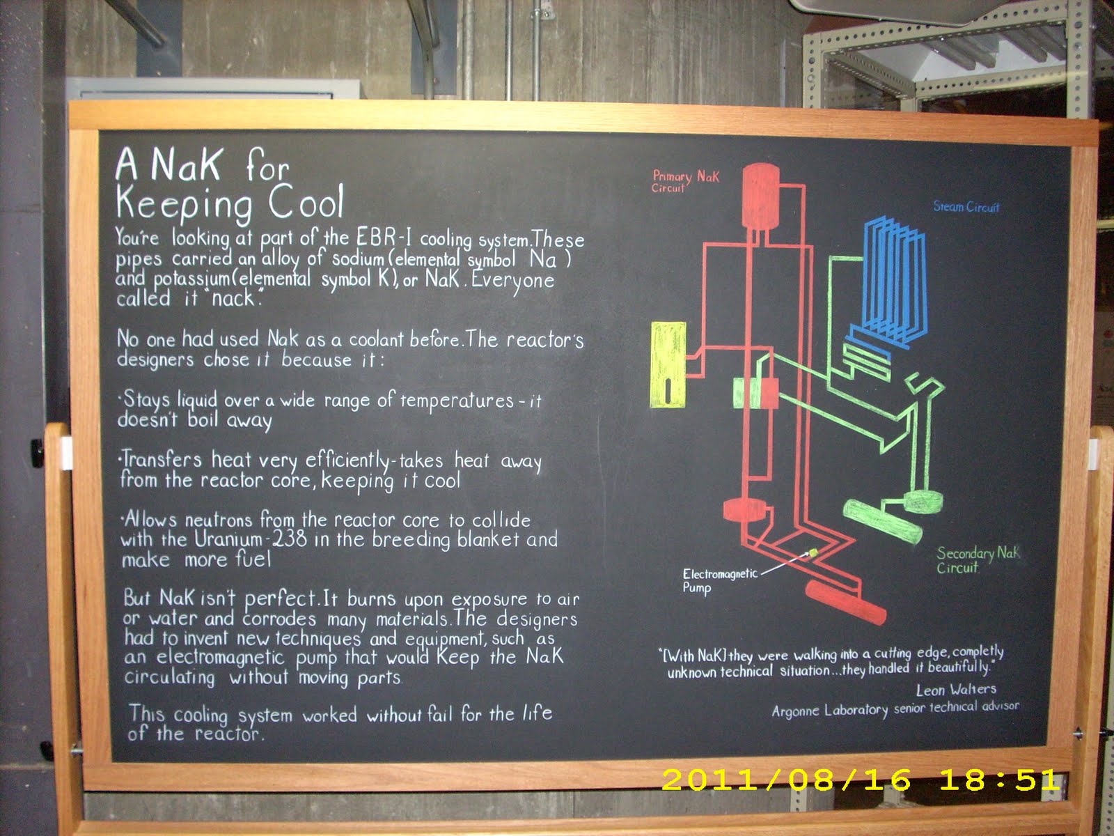
One thing that was unusual about this reactor is that, rather than being cooled with water (Ala Three Mile Island), it was cooled with a mixture of liquid sodium and liquid potassium:
They did have one little incident in 1955 when the reactor melted down:

Interestingly enough, the radioactive waste from Three Mile Island is being stored in the immediate area, also.
Anyway, fearing that I would start glowing in the dark, I continued on east on US20 to Idaho Falls. This is a really nice small city of about 50,000 souls. Right in the middle of town runs the Snake River, which is bounded by a Greenway on either side of the river itself:

In the foreground is a hydroelectric dam and in the background is the city's Mormon Temple. This was another view I thought was really pretty:

And one more:

Anyway, had a wonderful day, saw lots of interesting sights, weather was very nice. Tomorrow, it's east on US20 through Yellowstone National Park and on to Greybull, Wyoming for the night.
Miles today: 334. Total: 4,787.